Professional UAV Services

SEE THE SCENE.
WIN THE CASE.

FAA certified drone pilots delivering crash scene documentation prepared for legal use, live streaming, and 3D reconstruction for attorneys, law enforcement, and engineers. Available anywhere in the country. Fast.

Aerial documentation of semi-truck crash scene. Dover, Ohio.
Live Field Operation
Real Scene. Real Evidence.
Real Time.
Schedule Your Scene Documentation

AVT Drones deploys FAA certified pilots and advanced UAV platforms to your crash scene. We stream live footage directly to your screen anywhere in the world and deliver documentation prepared for legal use that gives your clients the clarity they deserve.

Core Services

What We Deliver.

01
Documentation
Aerial Crash Scene Evidence
High-resolution aerial photography and 4K video of accident scenes, captured by FAA-certified pilots. Every image documented for legal use from day one.
02
Streaming
Live Scene Streaming
Watch your crash scene in real time from your office, courtroom, or anywhere in the world. Our patent-pending PACC streams live HD footage directly to your screen.
03
Reconstruction
3D Scene Reconstruction
Centimeter-accurate, photogrammetry-based 3D models of crash scenes. Walk jurors through the scene as if they were standing there.
04
Survey Grade
RTK Photogrammetry
Centimeter-level, survey-grade data using Real-Time Kinematic positioning, with the method documented for expert review.
05
3D Data
Point Cloud Generation
Dense 3D point cloud datasets for engineering analysis, expert witness testimony, and technical reconstruction reports.
06
Mapping
Orthomosaic Mapping
Geometrically corrected aerial maps with true measurements. Scale-accurate scene documentation used in depositions and trial exhibits.
Our Process

How It Works.

01

You Call. We Deploy.

Contact our team and we move immediately. Our pilots are equipped and ready to deploy to your scene whether it is hours after an accident or weeks later for reconstruction documentation.

02

Live Streaming Begins

From the moment we arrive, you have eyes on the scene. Our PACC system streams live HD footage directly to your screen on your phone, tablet, or desktop. You see everything in real time from anywhere in the world.

03

Comprehensive Scene Documentation

Our FAA-certified pilots capture everything — high-resolution stills, 4K video, RTK-accurate survey data, and the full metadata record to support authenticating it. Nothing is missed.

04

Deliverables Built for Legal Use

You receive a complete evidence package — 3D models, orthomosaic maps, point clouds, video, and photography — formatted and ready for depositions, settlement negotiations, and trial.
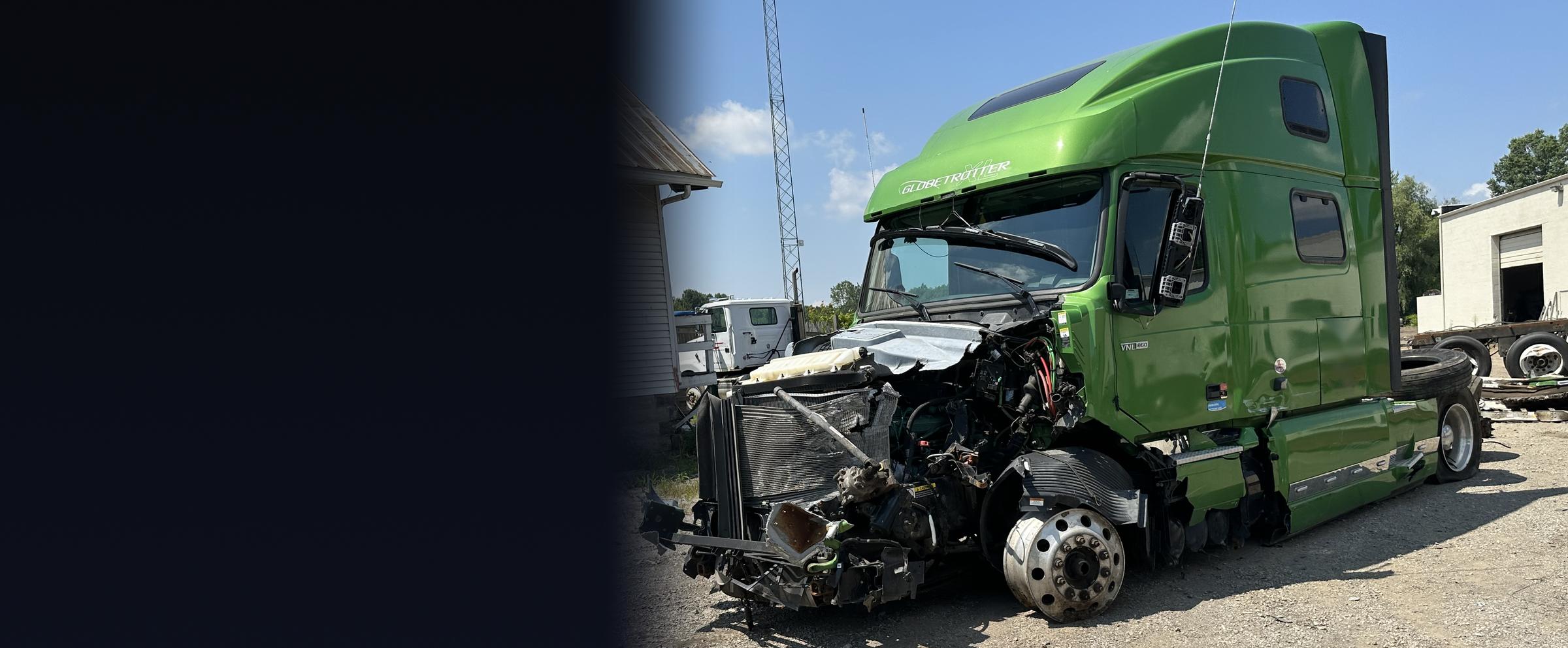
Heavy truck tractor with severe front-end collision damage, documented in the field for crash reconstruction
Field Proven

Heavy Trucking Crash Reconstruction. Built For Attorneys.

We document the roadway from above and the vehicles up close, then deliver measurements, 3D models, and maps your expert can build on.

Image from AVT field work. Identifying details withheld.

Who We Work With

Our Clients.

Personal Injury Attorneys
Defense Attorneys
Law Enforcement Agencies
Engineering Firms
Insurance Carriers
Municipalities & Government
Trucking Companies
Expert Witnesses
Risk Management Firms
Transparent Pricing

What To Expect.

Every scene is different. The pricing below reflects our standard service tiers for most cases. Complex scenes, multi-day deployments, or expedited requests may be quoted separately. Deliverables are prepared for legal use.

Tier 01. Standard
Aerial Documentation
$1,500+ / scene
Single-visit aerial documentation for standard crash scenes
  • High-resolution aerial photography
  • 4K video documentation
  • Geotagged, timestamped imagery
  • Full flight logs included
  • Deliverable package prepared for legal use
  • Delivered within 48 hours
Best for: Single vehicle incidents, premises liability, standard crash scenes
Tier 03. Premium
Full Reconstruction
$4,500+ / scene
Complete 3D reconstruction and survey-grade data package
  • Everything in Tier 02
  • Photogrammetry-based 3D scene model
  • Interactive browser-based 3D viewer
  • RTK survey-grade measurements
  • Point cloud dataset
  • Pre-testimony case consultation (testimony billed separately)
Best for: Fatality cases, complex multi-party litigation, engineering analysis
Base Rate
Standard hourly rate for consulting, custom project scopes, depositions, and non-packaged engagements: $295 / hour.
Call-Out Minimum
All on-site work carries a 4-hour minimum call-out at $295 / hour ($1,180), covering travel to the site, drone operation, and capture. Packaged scene pricing above meets or exceeds this minimum.
Add-On Services

Additional Rates.

RTK Survey
$2,000 / scene
Centimeter-accurate survey-grade data. LAS and E57 point cloud output for engineering analysis.
Live Streaming. PACC Deployment
$750 add-on
Real-time HD aerial feed via PACC. Can be added to any package.
Expert Witness. Half Day
$1,500 / half day
Deposition or court testimony support up to 4 hours.
Expert Witness. Full Day
$3,000 / full day
Full day deposition or court testimony availability.
Rush. Emergency Deployment
+50% surcharge
Same-day or next-day deployment on any package.
Travel Surcharge
$1.50 / mile
Applies to scenes beyond 60 miles from Cleveland, Ohio.
Note
All prices exclude applicable taxes. Multi-case retainer rates available. Contact us for volume pricing. Deliverables are formatted for use in depositions, settlement negotiations, and trial preparation. Whether any item is admitted or accepted is for the court to decide.

Need Scene Evidence
For Your Case?

Call us now or schedule a consultation. We deploy fast. Time is critical at accident scenes.

Call 216-545-1397 Schedule Consultation